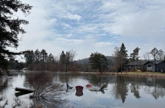
Cory Harris, the Watershed Services Coordinator demonstrates the floodplain mapping online service that went live on Jan. 29th, 2024. /THOMAS SMITH Staff
 By Thomas Smith
A public information session was held on Jan. 29 at the Minden Hills Community Centre in regards to flood preparation in the region. The session was presented in partnership by Haliburton County, Ganaraska Region Conservation Authority (GRCA) and Kawartha Conservation as a chance for residents of Haliburton County to experience a brand new floodplain mapping tool.
In addition to demonstrating to residents how to use the online tool, Cory Harris, the watershed services coordinator, presented on the value of Haliburton County’s Floodplain Mapping Project.
“The purpose of this information session is to get the word out about what we have been doing all these years,” said Harris in a private interview, prior to the presentation.
Harris says that it is very important to be aware of flood risks in your area. “Look up the area, try to understand what depths of flood mapping is in your area,” he said. “Make a plan as to what to do with flooding. Sandbagging and flood-proofing renovations are key things to consider.”
Dozens of Haliburton County residents lined up to search their properties using the new floodplain tool.
In the presentation, Harris assured that the residents of Haliburton County have become well versed in flood preparedness, response and recovery, but one lacking area was mitigation.
“The new model can be updated with important information, such as prioritizing culverts that are pinch points, we can map flood routes for emergency services,” he noted.
“Its genesis came about after a number of flooding events in the community. We are getting flooded repeatedly, what steps can we do? You know what areas are going to flood,” explained Harris, “and it makes it more resilient.”
The primary method of surveying and mapping the rivers and lakes was with Light Detecting and Ranging (LiDAR). Using airplanes with specialized surveying equipment, an accurate map improved upon the information from a 1986 survey. The first phase of the project commenced in 2018 in which the County applied for federal funding. After a successful application, the LiDAR data was acquired in 2019, and finally delivered in 2020.
“With good information we can make good decisions,” says Harris, “if emergency services know how a flood will progress through a community, they will know what doors to knock on first.”
This floodplain mapping will likely have an impact on insurance rates in the future.
“Once finalized, and implemented, and stamped,” said Harris. “Insurance companies will likely want to know this information.” Harris was unsure as to what extent this floodplain mapping will exactly have on previously existing insurance policies.
“If you see stuff that doesn’t look right,” pleads Harris, “we want to know about it.” The floodplain mapping tool can be explored online. In addition, Ganaraska Conservation has requested that if anyone sees an area that you know has flooded in the past and is not represented on the digital floodplain, to please contact Ganaraska Conservation at info@grca.on.ca
Comments on the floodplain will be accepted until Feb. 29, 2024.