The study area for these data gathering projects covered 2,800 square-kilometres of drainage area, 23 lakes and 42 dams.
 LiDAR and bathymetric data allows Conservation Authority to get clear picture of region’s flood plain
By STEPHEN PETRICK
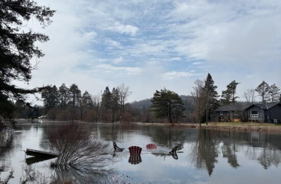
When the water rises, it can be dangerous and damaging to properties and homes. But gathering good data provides a great defence.
That was the gist of a highly scientific presentation by Ganaraska Region Conservation Authority officials to Haliburton County council.
The presentation by Watershed Services Coordinator Cory Harris and Remote Sensing Specialist Ian Jeffrey, made virtually at the Dec. 15 meeting, showed how new technology is helping the conservation authority get a more clear understanding of flood plains throughout the county.
The new data that’s been gathered will ensure municipal planners are more prepared for floods, as they’ll have a deeper understanding of the shape of land and know what homes and properties are at risk and how the rising water will likely behave.
Recent applications for senior government funding has come through, allowing for Ganaraska Conservation to embark on a LiDAR data acquisition project along the Gull and Brunt River systems.
LiDAR stands for light detection and ranging. LiDAR data can be gathered when an airplane, with lasers, flies over land and water. The lasers detect the contour of the Earth below and the data it collects generates colour-coded, seemingly-3D images, which give a sense of the height of buildings and vegetation, relative to the land’s surface.
“We have high quality LiDAR everywhere there’s a flood line, so that flood line is well understood and defensible,” said Jeffrey.
Ganaraska Conservation also received funding to gather bathymetric data for the Gull and Brunt River watersheds. This data is similar to LiDAR, but is gathered through sonar technology and focuses just on water bodies. That technology is attached to a remote-controlled water vessel.
This data acquisition project is still ongoing, but “so far it looks really good,” said Jeffrey.
The data will be used to create models of the flood plains. Those models “will show how the river will leave its banks, which shows how that behaviour will play out over time and ultimately give you good data to put into your planning process.”
If history is any indication, these data projects will be put to good use. Flooding episodes have happened along the Gull and Brunt river water systems in 2013, 2015, 2017 and 2019. As a result a partnership was formed between Haliburton County, Ganaraska Conservation and the nearby Kawartha Conservation to gather stronger data.
The study area for these data gathering projects covered 2,800 square-kilometres of drainage area, 23 lakes and 42 dams.
But the work isn’t over. The hydraulic models that the data creates will go through a peer review process in 2022, Harris said. Dams and structures in the project area are also subject to ongoing surveying. As the conservation authority now has precise information on how water can rise, it can maintain them properly.
Minden Hills Mayor Brent Devolin shared that his home was threatened by intense flooding in 2013. That event started a movement to gather new information and the current projects are the end of an important “nine-year journey,” he said. “Certainly the expertise that your group brings to this piece cannot be understated. It’s exciting to see this get to this point.”
Haliburton County Director of Planning Steven Stone said when the projects are fully complete, he expects information on the flood plain to be released to the public. The data will also likely influence future policy and planning, as the county will know where it’s not safe to build.
“It will drive community development in the future,” he said.