By Chad Ingram
Published Aug. 24 2017
Representatives of Minden Hills and Haliburton County met with provincial and federal officials during last week’s Association of Municipalities of Ontario conference looking for help with flood mitigation in the community.
Among those they met with were Ontario Minister of Natural Resources and Forestry Kathryn McGarry Ontario Minister of Municipal Affairs Bill Mauro and a staff member of federal Minister of Environment and Climate Change Catherine McKenna.
With them local politicians took a submission from Haliburton County and the Upper Trent Watershed Management Partnership or UTWMP.
UTWMP includes Haliburton County’s four lower-tier municipalities as well as the Municipality of Trent Lakes the Township of North Kawartha and the Coalition for Equitable Water Flow and as the submission reads “its primary purpose is to be a single voice for the Reservoir and Flow-Through (RaFT) lakes in the Haliburton sector of the Trent watershed on issues of water management. The goal of the partnership is to advance integrated water management across the entire Trent River watershed for the protection of aquatic resources the environment property values and local economies.”
The document poses a number of requests of the MNRF and/or MOECC.
The first is support from the MNRF for Haliburton County’s application for funding through the federal government’s National Disaster Mitigation Program.
That application is for 50 per cent funding for digital terrain model mapping of the Gull and Burnt river watersheds the county can use for flood risk assessment flood mapping and flood mitigation planning.
“It has to flow through the province first to have their seal of approval to come to the feds” said Minden Hills Reeve and Haliburton County Warden Brent Devolin.
“We are seeking MNRF support for hydrology and hydraulic studies from the Orillia Power Dam to the Gull Lake outlet for the purpose of establishing risk based flood plain mapping” the submission reads. “This will permit the evaluation of mitigating measures and protection of critical infrastructure.”
The document also seeks support from the MNRF and MOECC for LIDAR mapping of the reservoir system. LIDAR mapping uses a laser-based system to produce very detailed topographical images.
“We are seeking MOECC as well as MNRF support for climate change studies and planning as well as the development of new strategies for the management of the reservoir system to accommodate changing weather patterns” the submission reads. “This proposed initiative has tentative support from TSW [Trent Severn Waterway] but for which TSW cannot be the lead agency.”
A fifth request in the proposal is for support from the MNRF and MOECC for long term capacity and infrastructure plans for the reservoir system.
“We are seeking MNRF and MOECC support for the UTWMP and its initiatives” the submission concludes. “We respectfully request the active engagement of both MNRF and MOECC with Parks Canada and other stakeholders across the entire Trent River watershed for integrated and balanced water management planning in the face of our changing climate. We respectfully request that an appropriate ministry staff be assigned to the file. Our aquatic resources infrastructure property values and economies rely on it.”
Devolin said the reception at the conference in Ottawa last week left him feeling optimistic.
“It appears that was well-received” he said. “We had comment on the content of the information that’s in it that we are ahead of pretty well everybody else in the province dealing with this and we hate to say we’re becoming experts about this but we have a little more history.”
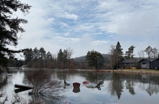
Minden Hills declared states of emergency in 2013 and 2017 due to severe flooding of the Gull River and there was near flooding in 2016. Lakes throughout the county’s reservoir system were also affected during these periods of flooding some hitting record highs this spring.
“To both levels of government we tried to make it quite clear that there needs to be a process and … potentially a permanent process for [flood mitigation] infrastructure operations and all that kind of thing.”
Algonquin Highlands Mayor Carol Moffatt who worked on the proposal also seemed pleased with the reception at the AMO conference.
“We know it’s a big sticky long-term plan” Moffatt said adding that the members of the CEWF have the knowledge experience and time to dedicate to the complicated issue. “We feel confident that we’ve done the research. We know the water’s not going to stop coming.”
Moffatt noted that the Green Infrastructure Fund could potentially be another source of funding for flood-related municipal projects.
“I think we’re moving the place markers in the right direction” Devolin said